Enhance preparedness with clear, accurate Emergency Response floor plans and maps
School districts nationwide are increasingly requiring the development and maintenance of Building-Level Emergency Plans to assist local and state agencies responding to emergency situations within a building.
To ensure emergency responders have fast, efficient access to critical life safety information and equipment, two of the primary requirements for Emergency Plans are:
- Accurate building floor plans with select data and asset locations.
- Campus maps showing entrances, exits, evacuation routes, access roads, etc.
ML Drawings® interactive floor-plan software helps busy Facility Managers easily generate, store, and update the required drawings and maps with all required information for PDF output and/or secure, permission-based live access.
NYSED 2024 Requirements
In June 2024, New York State Education Department (NYSED) issued new data requirements for Building-Level Emergency Plans to ensure all NYS school districts have consistent, clear, and accurate floor plans and area maps to assist first responders based on a school event. Below are summaries of these requirements.
Floor Plan Data
2024 NYSED Requirements
View the official NYSED memorandum.
- School name
- Street address
- Key to symbols used
- A compass indicating North
- Building entrances/exits
- Interior space names
- Windows, interior doors, room numbers
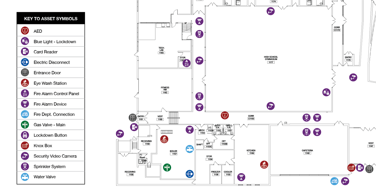
Floor Plan Assets
2024 NYSED Requirements
- Building entrances/exits
- Common areas/offices labeled
- Utility Shut Offs
- Fire Alarm Panels, Sprinkler Control Valves, Knox Box
- Emergency and Security equipment
Area Map Data
2024 NYSED Requirements
- School name and address
- Key to symbols
- A compass indicating north
- Buildings
- Building entrances/exits
- Assembly, evacuation, reunification areas
- Sports fields, playgrounds
Area Map Data
2024 NYSED Requirements
- Trees or other obstacles not obscuring the grounds
- Parking areas and traffic patterns on school property
- Outbuildings labeled
- Roads, streets, traffic patterns
- Additional aerial map(s)
- Potential emergency response areas
1. Floor Plans
ML Drawings Emergency Plans
ML Drawings is the perfect and easy solution to maintaining accurate floor plans that meet all the requirements for Building-Specific Emergency Plans.
With its asset mapping functionality and the ability to create filtered floor-plan views of specific emergency-related facility assets, ML Drawings can easily output PDFs with all required information with a single click.
Leverage your Architect’s original CAD files
The required data (listed above) and most of the architectural system related labels can be applied from the base Computer Aided Design (CAD) file from which floor plan PDFs are output.
If your district lacks a set of current floor plans that show windows, interior doors, room numbers, and common areas/offices identifiers, request a set from your Architect of Record.
Having as many required elements as possible from the original CAD file embedded into the floor plan PDF alleviates the need to survey these elements. Additionally, it’s all information that should be resident in the CAD file and only requires a few settings to output the PDF.
Customize ML Drawing® floor plans using filterable views
With more than 200 asset types, ML Drawings® can easily document the exact location of emergency equipment and related items including:
- Building entrances/exits with alphabetic or numeric identifiers
- Water, Gas, and Electric Shut Offs
- Fire Alarm Panels, Fire Sprinkler Control Valves, and Knox Box (Emergency Key Box)
- Emergency and Security Equipment including fire extinguishers, AEDs, video surveillance cameras, and Lockdown buttons.
In addition to PDFs, you can also provide local and state agencies with direct access to your district’s ML Drawings account where they could view live interactive floor plans with the ability to instantly drill down for more information about a device or system.
All views can be secured so only select staff, contractors, or agencies can view certain assets. This feature also facilitates first-time ML Drawings use by external support staff as views are limited to the systems and devices needed for a specific use case (e.g., Emergency Plans, HVAC Maintenance).
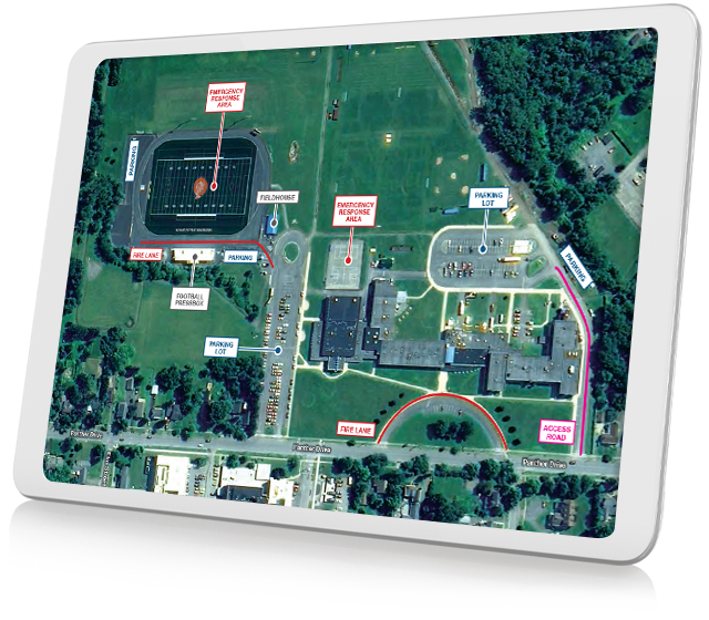
2. Area Maps
ML Drawings Emergency Plans
ML Drawings can also be used to Building-Level Emergency Use area maps that meet 2024 NYSED requirements outlined above.
With its asset mapping functionality and the ability to create filtered floor-plan views of specific emergency-related facility assets, ML Drawings can easily output PDFs with all required information with a single click.
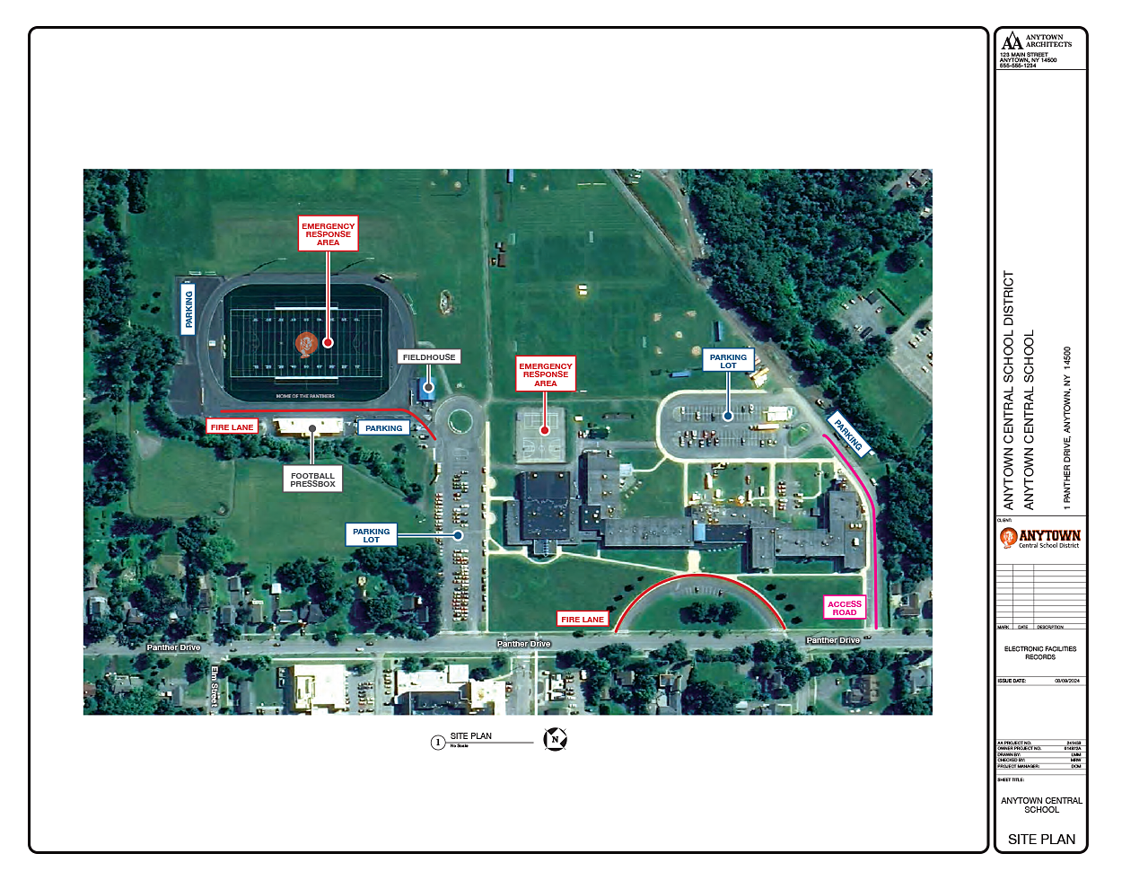
Leverage your GoogleMap base image file
There are a number of NYSED requirements that you can capture by using different settings available in Google Maps, Apple Maps, and many other free online mapping tools. Here are some tips and techniques to make the most of your base area map image file.
- Work from a desktop with a large high-quality monitor. You’ll appreciate the extra real estate.
- Make the mapping app display window the approximate aspect ratio (height:width) of a landscape letter-size page (11″ x 8.5″). This allows base maps to fit cleanly on a letter-size page when printed.
- If the Google Maps image is not up-to-date (i.e., recent construction is missing), try using Apple Maps which may have more recent images.
- Turn on Labels and the Satellite View so that all street and building names are included in the base map.
- Access the Map Details screen from the Layers > More command at the lower left of the GoogleMap screen.
- Select the Labels checkbox at the bottom of the Map Details screen.
- Select Satellite map type from the same window.
- Zoom out wide enough so you have a little extra margin of all four sides of your map. This will provide space to add stamps and markups in ML Drawings.
- Save your map as a landscape-oriented PDF using the “Print to PDF” command. ML Drawings currently only imports PDF for floor plans and campus maps.
Using ML Drawing® markup capabilities on your base Area Map
Once your area maps are saved as PDF files, open ML Drawings® and upload the files as Base Drawings.
Each Base Drawing/Area Map can now be marked up in MLD using its integrated editing tools. By saving the markups in ML Drawings you can be sure the source files can easily be updated in the future regardless of who’s responsible for the updates.
Emergency Plans MLD User Resources
The following resources are available to ML Drawings users to assist in the development of NYSED-compliant Building-Level Emergency Use floor plans and area maps.
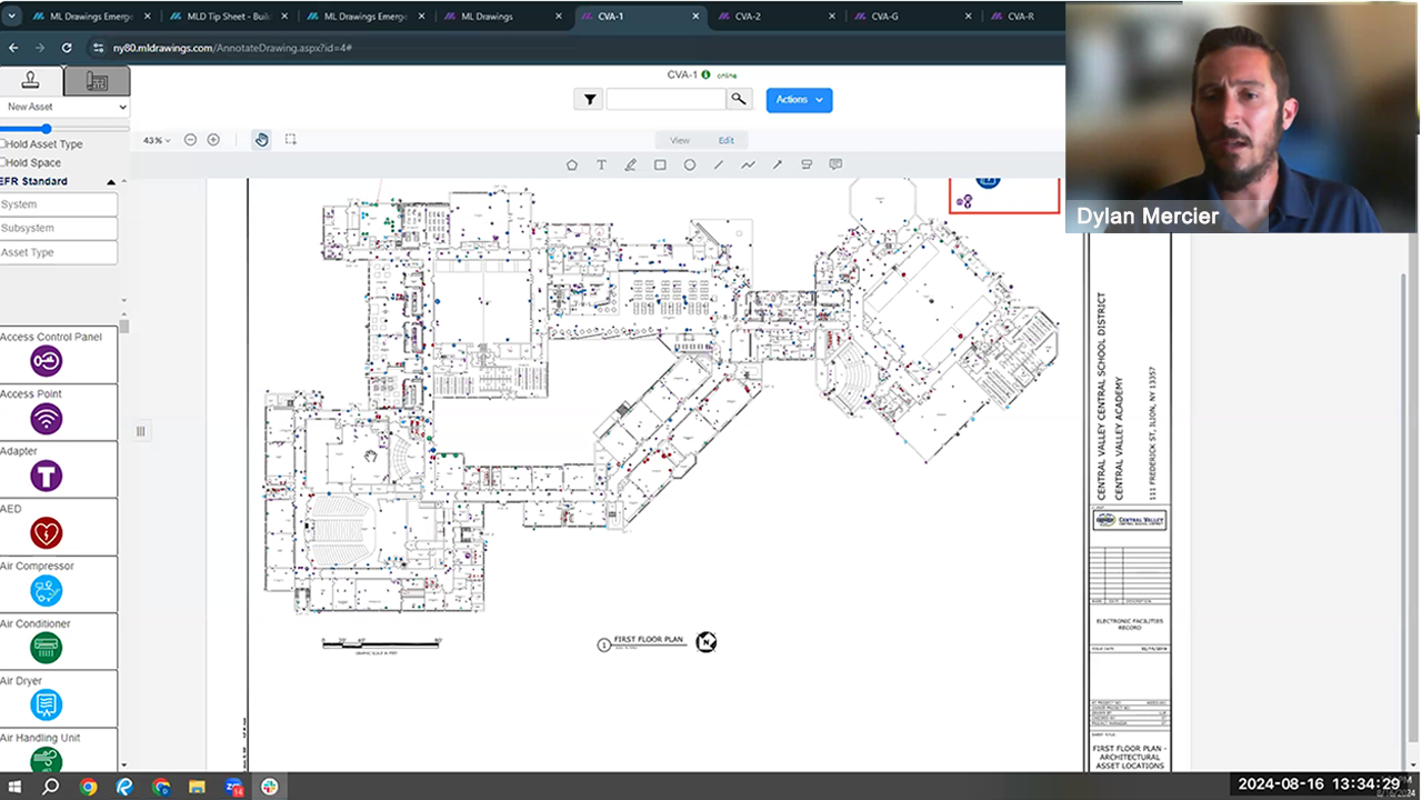
Emergency Use Plans Webcast
ML Drawings
In this 40-minute webinar, MasterLibrary Professional Services Manager Dylan Mercier demonstrates how floor plans can be easily stamped with different asset symbols to accurately show the locations of these critical items. The use of Asset Symbol Keys and other available free user resources are also discussed.
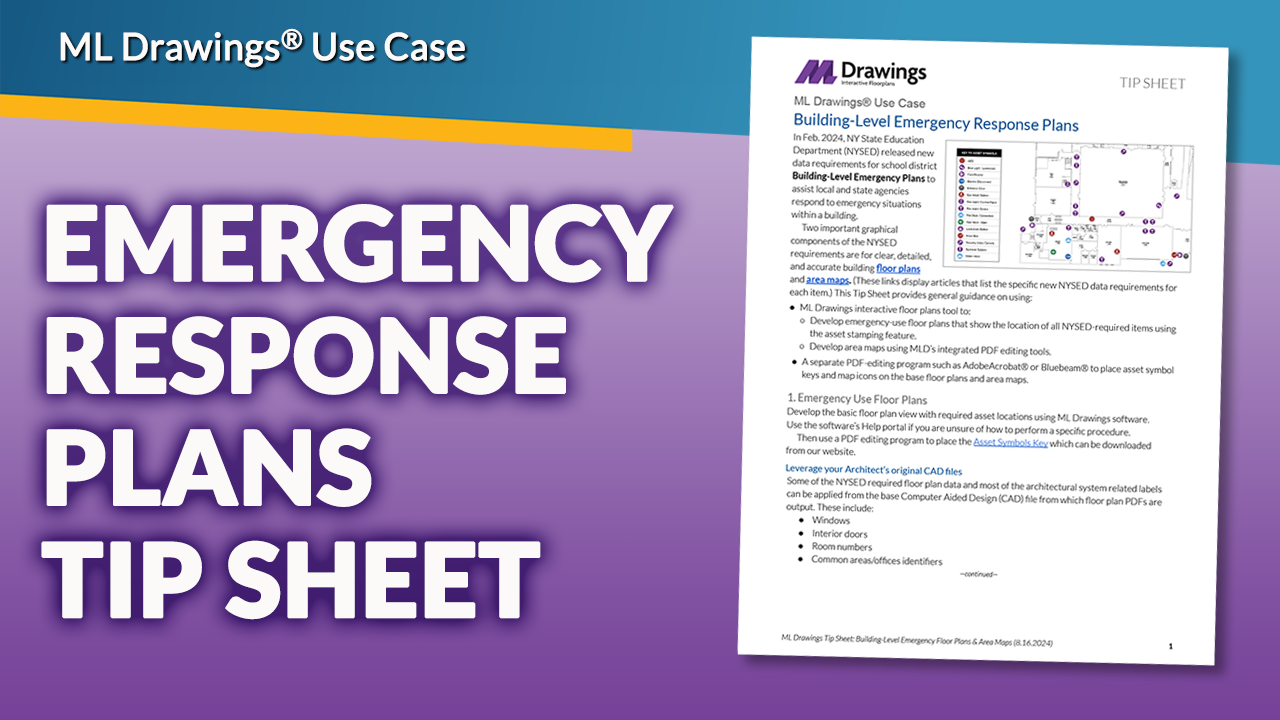
Emergency Use Plans Tip Sheet
ML Drawings
Learn how to stamp required asset types on floor plans with MLD; then use a PDF editor to drop in the Symbols Key.
Use MLD’s integrated PDF markup tools to develop area maps; then use a PDF editor to drop in the T1 Site Map frame and North compass point, if needed.
We're here to help
Emergency Response Plans
If you already subscribe to ML Drawings, your facilities and IT staff can develop Emergency Plan area maps that meet all 2024 NYSED requirements as described above.
If you need external help in either asset surveys and/or Emergency Plans floor plan/area map development, ML Pro Services can perform on-site surveys of appropriate assets and convert hand-annotated plans and maps into ML Drawings-based PDFs.

Schedule a one-on-one personalized demo.
Take an hour to talk with one of our expert team members for a no-pressure walk-through of the many features ML Drawings has to offer. This dedicated time allows you to go in-depth on any questions or features you’d like to understand better.
Schedule a Demo