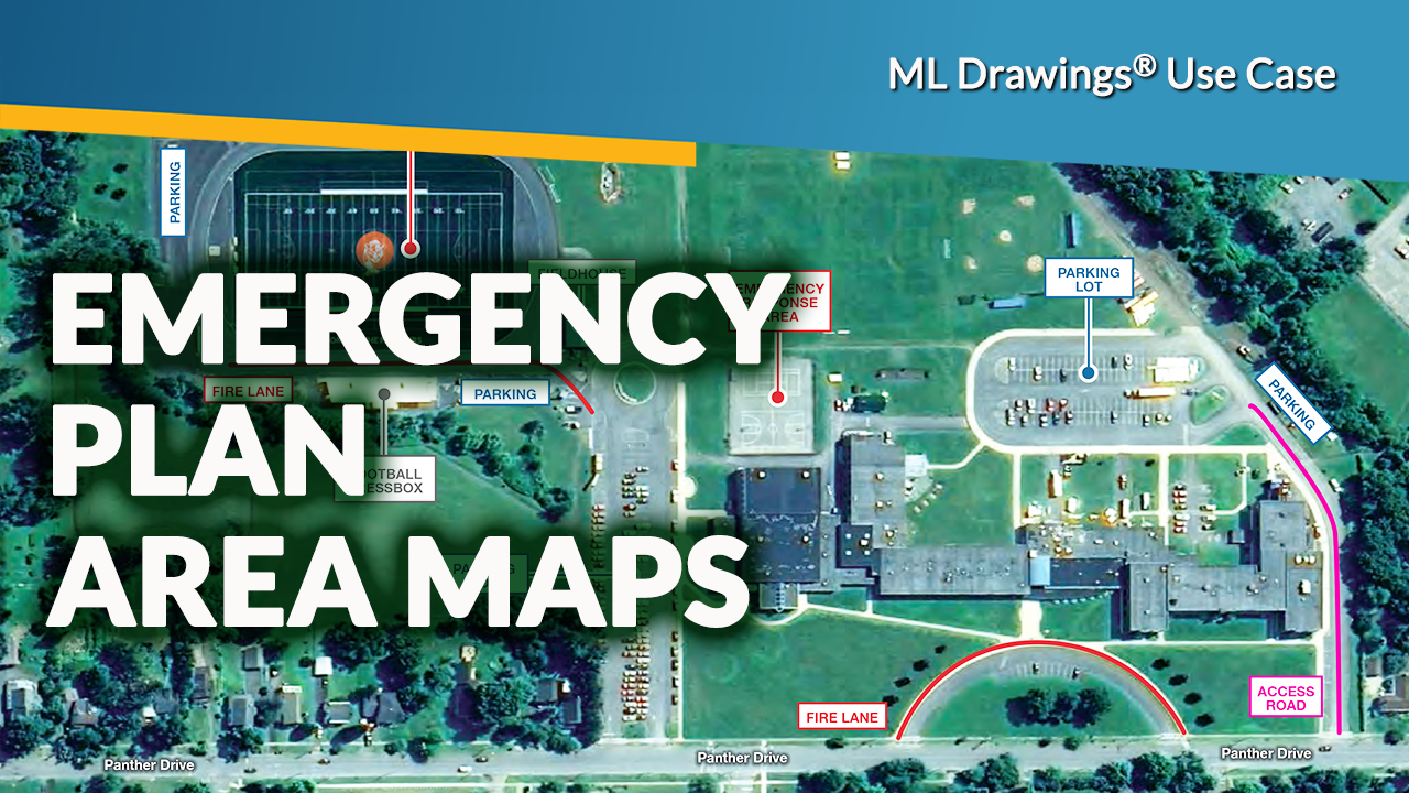
ML Drawings Emergency Plans use case: Area Maps
MasterLibrary
Meet new NYSED Emergency Plans Area Map requirements
ML Drawings Emergency Plans use case - Area Maps
The previous article in this ML Drawings Emergency Plans use case series focused on the need for accurate building floor plans with asset locations clearly shown along with other new NYSED data requirements.
This article will look at the new NYSED requirements for building maps and how
ML Drawings can be used to quickly create PDFs that meet them.
These new 2024 NYSED map data requirements were developed to “help school personnel in developing and submitting floor plans and area maps that will help guide emergency responders during an incident.”
This article contains a summary of the Area Maps tips from NYSED’s Feb. ’24 Building-Level Emergency Response Plans: Floor Plan and Area Map Tips for Creating and Uploading Your Floor Plan and Area Map (PDF). View the complete NYSED Tip Sheet (PDF).
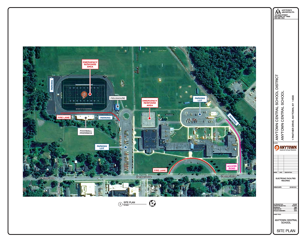
Area Map Requirements
NYSED's 2024 Building Emergency Plans now require that area maps contain the following information.
- School name and address.
- A key to define any symbols used.
- A compass indicating North
- Buildings labeled (concession stand, school, maintenance shed, bus garage, etc.).
- Building entrances/exits labeled (including service entrances).
- Assembly, evacuation and/or reunification area(s) labeled. Include travel routes to these areas.
- Sports fields and playgrounds clearly labeled. Include any satellite images of athletic fields and travel routes to these fields.
- Trees or other obstacles not obscuring the grounds on satellite images.
- Parking areas and traffic patterns on school property clearly identified and marked with labels and arrows (For example, staff parking, visitor parking, one-way traffic, etc.; student pickup, purchased deliveries, emergency access, etc.).
- Outbuildings clearly labeled (e.g., maintenance shed, concession stand, etc.).
- Roads, streets, and traffic patterns clearly marked.
- If necessary, provide additional aerial map(s) with street names and surrounding buildings, waterways, etc. clearly labeled.
- Other areas on your grounds that first responders have designated as potential emergency response areas (e.g., helicopter landing sites, community staging areas, etc.).
Take the quick route to area maps with ML Drawings.
In addition to its ability to easily create Emergency Use floor plans, ML Drawings can also be used to develop Emergency Use area maps that meet all new 2024 NYSED requirements.
As noted in NYSED’s Tip Sheet, the starting point for an accurate area map is a software application such as Google Maps®.
Leverage your GoogleMap base image file
There are a number of NYSED requirements that you can capture by using different settings available in Google Maps, Apple Maps, and many other free online mapping tools. Here are some tips and techniques to make the most of your base area map image file.
- Work from a desktop with a large high-quality monitor. You’ll appreciate the extra real estate.
- Make the mapping app display window the approximate aspect ratio (height:width) of a landscape letter-size page (11″ x 8.5″). This allows base maps to fit cleanly on a letter-size page when printed.
- If the Google Maps image is not up-to-date (i.e., recent construction is missing), try using Apple Maps which may have more recent images.
- Turn on Labels and the Satellite View so that all street and building names are included in the base map.
- Access the Map Details screen from the Layers > More command at the lower left of the GoogleMap screen.
- Select the Labels checkbox at the bottom of the Map Details screen.
- Select Satellite map type from the same window.
- Zoom out wide enough so you have a little extra margin of all four sides of your map. This will provide space to add stamps and markups in ML Drawings.
- Save your map as a landscape-oriented PDF using the “Print to PDF” command. ML Drawings currently only imports PDF for floor plans and campus maps.
Using ML Drawing® markup capabilities on your base Area Map
Once your area maps are saved as PDF files, open ML Drawings® and upload the files as Base Drawings.
Each Base Drawing/Area Map can now be marked up in MLD using its integrated editing tools. By saving the markups in ML Drawings you can be sure the source files can easily be updated in the future regardless of who’s responsible for the updates.
Let ML Pro Services do the heavy lifting for you
If you already subscribe to ML Drawings, your facilities and IT staff can develop Emergency Plan area maps that meet all 2024 NYSED requirements as described above.
If you need external help in either asset surveys and/or Emergency Plans floor plan/area map development, ML Pro Services can perform on-site surveys of appropriate assets and convert hand-annotated plans and maps into ML Drawings-based PDFs.
Schedule a demo today.
If your district doesn't subscribe to ML Drawings, see what you're missing on our website. Then schedule a demo to see how this asset-mapping solution can meet your district’s specific needs.
Schedule a Demo